Carolina
Business
History
With limited ocean ports and poor river navigation, North Carolina faced difficult transportation obstacles in its early years. Most trade went through Virginia or South Carolina. In order to improve transportation, numerous attempts were inaugurated during the late 1700s and early 1800s.


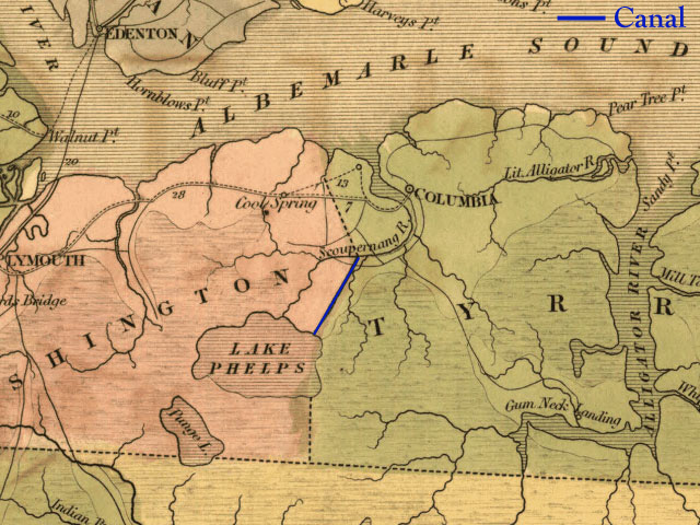
Collins (Somerset) Canal (click for 1839 Map)
A canal completed in 1788 connecting Lake Phelps with the Scuppernong River. Dug by slave labor, the canal was used for navigation of lumber, rice and other materials, as well as to drain surrounding land. Length: 6 miles. (near Cresswell, NC)
Dismal Swamp Canal (click for 1839 Map)
A canal was first suggested in 1728. In December 1786, Virginia and North Carolina leaders reached an agreement to build the Dismal Swamp Canal to connect the Pasquotank River and Albemarle Sounds to Deep Creek, VA, and the Norfolk tidewater area. A private company, the Dismal Swamp Canal Company began construction in 1793 at both ends of the route. By 1796, costs were far exceeding projections, so digging was temporarily halted, while work began on building a road to connect the two canal segments. The road was completed in 1802 making a freight route possible.
Work resumed on the canal digging and the completed canal was open in 1805 to flatboat and barge traffic. The canal would always be affected by dry seasons and droughts. In 1814, a 20-ton, decked vessel passed through the canal, marking the first large boat to make the transit.
In 1827 - 1829, improvements were made in the canal to allow larger vessels with deeper drafts. In 1892, the Lake Drummond Canal & Water Company takes over the ownership and operation of the canal. The federal government purchased the canal in 1929.
Running basically north and south, this is the oldest man-made canal in continuous operation in the United States.
Benjamin Jones of Camden Co. (NC) was the only North Carolinian on the first board of directors of the Dismal Swamp Canal Company, since most of the financial support for the effort came from Virginia.
Length: 22 miles; Width (after 1829): 40 feet; Depth: originally 4 feet, later increased to 6.5 feet.
Cross Canal (click for 1839 Map)
This canal was opened in 1822. Ford B. Sawyer and Samuel Proctor were the initial proprietors of the Cross Canal in 1816 acquiring land to connect the Dismal Swamp Canal to Gates County (NC). The canal ran parallel to the state border.
Length: 11 miles.
Roanoke Navigation Company & the Weldon (Roanoke) Canal
(click for 1839 Map)
The Roanoke Navigation Company was chartered in 1812 and began construction in 1817 to build the Roanoke (sometimes referred to as the Weldon) canal around a nine-mile, 85-foot drop at Great Falls on the Roanoke River. The work was completed in 1823. This canal opened boat traffic from the valleys of the Dan and Staunton to the North Carolina coast.
Tolls collected from boats traveling the canal were $1,825.00 in 1830 and $12,190.22 in 1840. Railroad connections at and near Weldon, NC, in 1840 began a shift in freight transportation. The canal was abandoned around 1850.
Length: 12 miles in length.
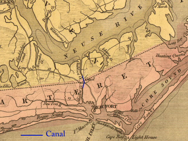
Clubfoot & Harlowe (Harlow's) Creek Canal (click for 1839 Map)
Discussed prior to the Revolution, the canal never got underway in the 18th Century. Construction and planning got underway in 1795. In 1815, the North Carolina legislature authorized the formation of the Clubfoot and Harlow's Creek Canal Company. A turf lock was completed in 1821, but failed. A more structurally sound lock was finished toward the end of the 1820s. The canal was in full operation by 1827. This canal linked Beaufort, NC and Pamlico Sound & New Bern(e). When the lock at Harlowe fell into disrepair in 1856, the canal was abandoned.
In 1880 it was re-opened as the New Berne and Beaufort Canal. The government acquired the canal in 1891.
Note: In 1911, a new canal was created two miles east of this waterway — Adams Creek-Cross Creek Canal.
Length: 5-6 miles. Depth: 4 feet.
Bean Shoals Canal
Designed to bypass some falls in the upper Yadkin River, this never-completed, three-mile canal was worked on from 1820 to 1825 by the Yadkin Navigation Company. There were to be three wooden locks. Construction required an extensive retaining wall be built between the canal and river. The project was so expensive that only 2 miles of the canal were built and the effort was abandoned without the canal ever being operational. A retaining wall remains.
Albemarle & Chesapeake Canal
The first canal company for this route was initially authorized in 1772. In 1809, another legislative bill created the Great Coastwise Canal & River Navigation Company to build the waterway. More private companies would be authorized and supercede this company over the decades.
Canal construction finally began in 1855. Opened in 1859, this canal provided access to larger ships than the Dismal Swamp Canal. The Albemarle & Chesapeake Canal linked Norfolk area (through the south branch of the Elizabeth River) to New Bern and Washington, NC through the canal (North Landing River & Currituck/Albemarle Sounds). The federal government bought the canal in 1913.
Length: 10 miles. Depth: originally 6 feet, later increased to 8-foot draft.
In addition to canals, there were numerous companies incorporated to deal in other ways with making North Carolina's rivers more navigable. Their actions included building locks, constructing short canals around rapids, dredging channels and clearing obstacles. Among these companies was the Cape Fear Navigation Company (attempted to build short canals and locks in the 1820s but suspended effort until the 1840s — only one steamer known to use these short canals (one is the Lockville Canal). The Cape Fear Navigation Company was chartered in 1796).
Other efforts to either build canals or improve rivers were the Neuse Navigation Company (1818 - 1825), Yadkin Navigation Company (see Bean Shoals Canal, above), the Tar River Navigation Company, the Catawba Navigation Company (1827 - ; president Isaac Thomas Avery) and the New River Navigation Company. Very little came out of these efforts as state financial support was minimal ($185,000 in stock for all of these companies) compared to the amount that might actually be required.
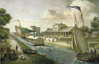
1830 rendering of the Dismal Swamp
Canal and Halfway House (Lake
Drummond Hotel) which saddled
the Virginia and North Carolina
state line.
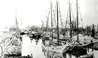
The Dismal Swamp Canal near
Elizabeth City.
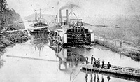
Dredging of the Albemarle &
Chesapeake Canal, circa 1905.
Industries Laureates Contact
Us Home
2006 Copyright. CommunicationSolutions/ISI
for web site and content.